
Thank you for supporting this site ❤️
Make a donation
Make a donation
Taynuilt topographic map
Click on the map to display elevation.
Thank you for supporting this site ❤️
Make a donation
Make a donation
About this map
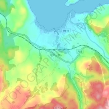
Name: Taynuilt topographic map, elevation, terrain.
Location: Taynuilt, Argyll and Bute, Scotland, PA35 1JZ, United Kingdom (56.40905 -5.25935 56.44905 -5.21935)
Average elevation: 49 m
Minimum elevation: -1 m
Maximum elevation: 146 m
Thank you for supporting this site ❤️
Make a donation
Make a donation