
Make a donation
Marienloh topographic map
Click on the map to display elevation.
Make a donation
Marienloh
Marienloh liegt zwischen der Kernstadt Paderborn und Bad Lippspringe im Norden der Paderborner Hochfläche westlich des Eggegebirges auf einer Höhe von 128 m ü. NN. Durch Marienloh fließt die Beke, welche am Westrand der Ortschaft in die Lippe einmündet.
Make a donation
About this map
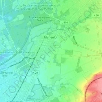
Name: Marienloh topographic map, elevation, terrain.
Average elevation: 131 m
Minimum elevation: 109 m
Maximum elevation: 191 m
Make a donation
Other topographic maps
Click on a map to view its topography, its elevation and its terrain.
Barkhausen
Deutschland > Nordrhein-Westfalen > Kreis Paderborn > Paderborn > Wewer
Average elevation: 139 m
Tallesee Mittelsee
Deutschland > Nordrhein-Westfalen > Kreis Paderborn > Paderborn
Average elevation: 118 m
Make a donation
Nesthauser See
Deutschland > Nordrhein-Westfalen > Kreis Paderborn > Paderborn > Sande
Average elevation: 101 m
Habichtsee
Deutschland > Nordrhein-Westfalen > Kreis Paderborn > Paderborn > Sennelager
Average elevation: 112 m