
Berne topographic map
Interactive map
Click on the map to display elevation.
About this map
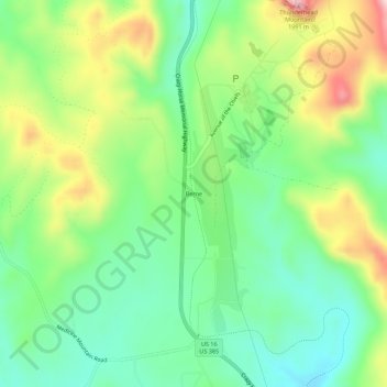
Name: Berne topographic map, elevation, terrain.
Location: Berne, Custer County, South Dakota, United States (43.79748 -103.65881 43.83748 -103.61881)
Average elevation: 1,799 m
Minimum elevation: 1,693 m
Maximum elevation: 1,984 m
Other topographic maps
Click on a map to view its topography, its elevation and its terrain.
Custer State Park
United States > South Dakota > Custer County
Custer State Park, Custer County, South Dakota, United States
Average elevation: 1,413 m
Stockade Lake
United States > South Dakota > Custer County
Stockade Lake, Custer County, South Dakota, United States
Average elevation: 1,616 m
Hermosa
United States > South Dakota > Custer County
Hermosa, Custer County, South Dakota, United States
Average elevation: 1,010 m
Spokane
United States > South Dakota > Custer County
Spokane, Custer County, South Dakota, United States
Average elevation: 1,394 m
Fourmile
United States > South Dakota > Custer County
Fourmile, Custer County, South Dakota, United States
Average elevation: 1,669 m
Sylvan Lake Resort
United States > South Dakota > Custer County
Sylvan Lake Resort, Custer County, South Dakota, United States
Average elevation: 1,889 m
State Game Lodge
United States > South Dakota > Custer County
State Game Lodge, Custer County, South Dakota, United States
Average elevation: 1,348 m
Buffalo Gap
United States > South Dakota > Custer County
Buffalo Gap, Custer County, South Dakota, 57722, United States
Average elevation: 1,005 m
Wind Cave National Park
United States > South Dakota > Custer County
Wind Cave National Park, Custer County, South Dakota, United States
Average elevation: 1,315 m