
Anerley topographic map
Click on the map to display elevation.
About this map
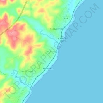
Name: Anerley topographic map, elevation, terrain.
Average elevation: 25 m
Minimum elevation: 0 m
Maximum elevation: 111 m
Other topographic maps
Click on a map to view its topography, its elevation and its terrain.
Umzimkulu River
South Africa > KwaZulu-Natal > Ugu District Municipality > Hibiscus Coast Local Municipality > Port Shepstone
Average elevation: 135 m
Mpenjati Nature Reserve
South Africa > KwaZulu-Natal > Ugu District Municipality > Hibiscus Coast Local Municipality > Palm Beach
Average elevation: 25 m
Ivy Beach
South Africa > KwaZulu-Natal > Ugu District Municipality > Hibiscus Coast Local Municipality > Leisure Bay > Ivy Beach
Average elevation: 21 m