
Make a donation
Monroe County topographic map
Click on the map to display elevation.
Make a donation
Monroe County
According to the Trewartha climate classification system, the higher elevation Pocono Plateau Region of Monroe County has a Temperate Continental climate (Dc) with warm summers (b), cold winters (o) and year-around precipitation (Dcbo). Dcbo climates are characterized by at least one month having an average mean temperature ≤ 32.0 °F (0.0 °C), four to seven months with an average mean temperature ≥ 50.0 °F (10.0 °C), all months with an average mean temperature < 72.0 °F (22.2 °C) and no significant precipitation difference between seasons. Although most summer days are comfortably humid on the Pocono Plateau, episodes of heat and high humidity can occur with heat index values > 92 °F (33 °C). Since 1981, the highest air temperature was 93.0 °F (33.9 °C) on 07/15/1995, and the highest daily average mean dew point was 70.8 °F (21.6 °C) on 08/01/2006. July is the peak month for thunderstorm activity which correlates with the average warmest month of the year. Since 1981, the wettest calendar day was 6.43 inches (163 mm) on 09/30/2010. During the winter months, the plant hardiness zone is 5b with an average annual extreme minimum air temperature of −11.2 °F (−24.0 °C). Since 1981, the coldest air temperature was −22.9 °F (−30.5 °C) on 01/21/1994. Episodes of extreme cold and wind can occur with wind chill values < −24 °F (−31 °C). The average snowiest month is January which correlates with the average coldest month of the year. Ice storms and large snowstorms depositing ≥ 12 inches (30 cm) of snow occur nearly every year, particularly during nor’easters from December through March.
Make a donation
About this map
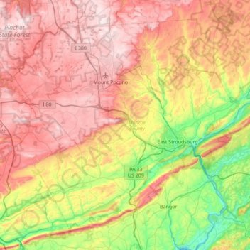
Name: Monroe County topographic map, elevation, terrain.
Location: Monroe County, Pennsylvania, United States (40.81484 -75.64929 41.25213 -74.96660)
Average elevation: 361 m
Minimum elevation: 56 m
Maximum elevation: 684 m
Make a donation
Other topographic maps
Click on a map to view its topography, its elevation and its terrain.
Valley Forge
United States > Pennsylvania > Chester County > Schuylkill Township
Average elevation: 78 m
Waterville
United States > Pennsylvania > Lycoming County > Cummings Township
Average elevation: 388 m
Make a donation
Booths Corner
United States > Pennsylvania > Delaware County > Bethel Township
Average elevation: 105 m
Breezewood
United States > Pennsylvania > Bedford County > East Providence Township
Average elevation: 413 m
East Texas
United States > Pennsylvania > Lehigh County > Lower Macungie Township
Average elevation: 126 m
Make a donation
Albrightsville
United States > Pennsylvania > Carbon County > Kidder Township
Average elevation: 498 m
Knickerbocker
United States > Pennsylvania > Chester County > Willistown Township
Average elevation: 127 m
Make a donation
Drumore Center
United States > Pennsylvania > Lancaster County > Drumore Township
Average elevation: 175 m
Dingmans Ferry
United States > Pennsylvania > Pike County > Delaware Township
Average elevation: 192 m
Mount Nebo Park
United States > Pennsylvania > Monroe County > East Stroudsburg > Twin Falls
Average elevation: 185 m
Make a donation
Cowden
United States > Pennsylvania > Washington County > Cecil Township > Cecil
Average elevation: 346 m
Make a donation
Keown Station
United States > Pennsylvania > Allegheny County > Ross Township
Average elevation: 344 m
Make a donation
Make a donation
New Enterprise
United States > Pennsylvania > Bedford County > South Woodbury Township
Average elevation: 397 m
Blue Knob
United States > Pennsylvania > Bedford County > Pavia Township
Blue Knob (elevation 3,146 feet (959 m)) is a summit in the eastern United States with a broad dome that is the northernmost 3,000-footer in the Allegheny Mountains. It is the highest point in Bedford County, Pennsylvania.
Average elevation: 792 m
Make a donation
Sinnemahoning
United States > Pennsylvania > Cameron County > Gibson Township
Average elevation: 406 m
Saint Benedict
United States > Pennsylvania > Cambria County > West Carroll Township
Average elevation: 582 m
English Center
United States > Pennsylvania > Lycoming County > Pine Township
Average elevation: 444 m
Make a donation
Tyrrel Farm Corners
United States > Pennsylvania > Venango County > Allegheny Township
Average elevation: 478 m
Fort Hunter
United States > Pennsylvania > Dauphin County > Middle Paxton Township
Average elevation: 149 m
Green Village
United States > Pennsylvania > Franklin County > Greene Township
Average elevation: 207 m
Make a donation
Normalville
United States > Pennsylvania > Fayette County > Springfield Township
Average elevation: 486 m
Arnold City
United States > Pennsylvania > Fayette County > Washington Township
Average elevation: 303 m
Make a donation
Three Tuns
United States > Pennsylvania > Montgomery County > Upper Dublin Township > Maple Glen
Average elevation: 101 m
Hidden Valley
United States > Pennsylvania > Montgomery County > Upper Merion Township
Average elevation: 47 m
Make a donation
Strafford
United States > Pennsylvania > Chester County > Tredyffrin Township
Average elevation: 133 m
West Pittsburg
United States > Pennsylvania > Lawrence County > Taylor Township
Average elevation: 279 m
Make a donation
Robinson
United States > Pennsylvania > Indiana County > West Wheatfield Township
Average elevation: 397 m
Hazelton Mills
United States > Pennsylvania > McKean County > Bradford Township
Average elevation: 598 m
Fogelsville
United States > Pennsylvania > Lehigh County > Upper Macungie Township
Average elevation: 155 m
Make a donation
Mount Bethel
United States > Pennsylvania > Northampton County > Upper Mount Bethel Township
Average elevation: 156 m
Rosemount
United States > Pennsylvania > York County > Spring Garden Township
Average elevation: 167 m
Make a donation
Reservoir Heights
United States > Pennsylvania > Dauphin County > Upper Paxton Township
Average elevation: 189 m
Skytop
United States > Pennsylvania > Monroe County > Barrett Township
Skytop is an unincorporated community in Barrett Township, Monroe County, Pennsylvania, United States. Located north of Mountainhome, it is accessible by local roads off Route 390. Its elevation is 1,562 feet (476 m), and it is located at 41°13′40″N 75°14′18″W / 41.22778°N 75.23833°W /…
Average elevation: 469 m
Make a donation
Ricketts Glen State Park
United States > Pennsylvania > Luzerne County > Fairmount Township
The state's original plans for the new park included building an inn, an 18-hole golf course and country club, and a winter sports complex for skiing, ice boating, and tobogganing, as well as a beach with bathing facilities, cabins, and a tent camping area. Only the last three were actually built, all south of…
Average elevation: 588 m
Mount Cobb
United States > Pennsylvania > Lackawanna County > Jefferson Township
Average elevation: 529 m
Pipersville
United States > Pennsylvania > Bucks County > Bedminster Township
Average elevation: 125 m
Make a donation
Pastorius Park
United States > Pennsylvania > Philadelphia County > Philadelphia
Average elevation: 108 m
Danielsville
United States > Pennsylvania > Northampton County > Lehigh Township
Average elevation: 254 m
Make a donation
Blue Mountain
United States > Pennsylvania > Monroe County > Eldred Township
The ridge of Blue Mountain runs for 150 miles (240 km) through Pennsylvania, reaching an elevation of 2,270 feet (690 m) above sea level just north of the Pennsylvania Turnpike, near the borough of Newburg. Most of the ridgecrest, however, only reaches between 1,400 and 1,700 feet (430 and 520 m) in elevation.…
Average elevation: 242 m
Park Place
United States > Pennsylvania > Schuylkill County > Mahanoy Township
Average elevation: 515 m
Portlamd Waterfront Park
United States > Pennsylvania > Northampton County > Portland
Average elevation: 118 m
Make a donation
Stevens Point
United States > Pennsylvania > Susquehanna County > Harmony Township
Average elevation: 434 m
Pendle Hill
United States > Pennsylvania > Delaware County > Nether Providence Township
Average elevation: 61 m
Make a donation
Longwood Gardens
United States > Pennsylvania > Chester County > East Marlborough Township
Average elevation: 125 m
Nottingham County Park
United States > Pennsylvania > Chester County > West Nottingham Township
Average elevation: 137 m
Make a donation
Marble Hall
United States > Pennsylvania > Montgomery County > Whitemarsh Township
Average elevation: 64 m
Circleville
United States > Pennsylvania > Westmoreland County > North Huntingdon Township
Average elevation: 333 m
Make a donation
Chadds Ford Township
United States > Pennsylvania > Delaware County > Chadds Ford Township
Average elevation: 101 m
Strawberry Mansion
United States > Pennsylvania > Philadelphia County > Philadelphia
Average elevation: 31 m
Reinholds
United States > Pennsylvania > Lancaster County > West Cocalico Township
Average elevation: 159 m
Make a donation
Langhorne Gardens
United States > Pennsylvania > Bucks County > Middletown Township
Average elevation: 45 m
Make a donation
Hanover Junction
United States > Pennsylvania > York County > North Codorus Township
Average elevation: 187 m
Champion
United States > Pennsylvania > Allegheny County > North Fayette Township
Average elevation: 360 m
Make a donation