
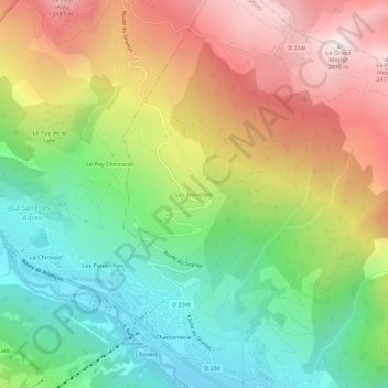
Les Tronchets topographic map
Interactive map
Click on the map to display elevation.
About this map
Name: Les Tronchets topographic map, elevation, terrain.
Average elevation: 1,845 m
Minimum elevation: 1,334 m
Maximum elevation: 2,511 m
Other topographic maps
Click on a map to view its topography, its elevation and its terrain.
Col de Granon
France > Provence-Alpes-Côte d'Azur > Hautes-Alpes > Saint-Chaffrey
Col de Granon, Saint-Chaffrey, Briançon, Hautes-Alpes, Provence-Alpes-Côte d'Azur, France métropolitaine, 05330, France
Average elevation: 2,291 m
L'Envers
France > Provence-Alpes-Côte d'Azur > Hautes-Alpes > Saint-Chaffrey
L'Envers, Saint-Chaffrey, Briançon, Hautes-Alpes, Provence-Alpes-Côte d'Azur, France métropolitaine, 05330, France
Average elevation: 1,646 m
Chantemerle
France > Provence-Alpes-Côte d'Azur > Hautes-Alpes > Saint-Chaffrey
Chantemerle, Saint-Chaffrey, Briançon, Hautes-Alpes, Provence-Alpes-Côte d'Azur, France métropolitaine, 05330, France
Average elevation: 1,638 m
Via ferrata Rocher blanc facile
France > Provence-Alpes-Côte d'Azur > Hautes-Alpes > Saint-Chaffrey
Via ferrata Rocher blanc facile, La Ricelle, Saint-Chaffrey, Briançon, Hautes-Alpes, Provence-Alpes-Côte d'Azur, France métropolitaine, 05330, France
Average elevation: 2,211 m