
Thank you for supporting this site ❤️
Make a donation
Make a donation
Tepechitlán topographic map
Click on the map to display elevation.
Thank you for supporting this site ❤️
Make a donation
Make a donation
About this map
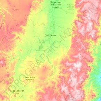
Name: Tepechitlán topographic map, elevation, terrain.
Location: Tepechitlán, Zacatecas, 99750, Mexico (21.50096 -103.55556 21.72826 -103.15849)
Average elevation: 2,045 m
Minimum elevation: 1,404 m
Maximum elevation: 2,662 m
Thank you for supporting this site ❤️
Make a donation
Make a donation
Other topographic maps
Click on a map to view its topography, its elevation and its terrain.