
Thank you for supporting this site ❤️
Make a donation
Make a donation
uMngeni topographic map
Click on the map to display elevation.
Thank you for supporting this site ❤️
Make a donation
Make a donation
About this map
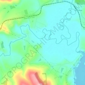
Name: uMngeni topographic map, elevation, terrain.
Average elevation: 1,083 m
Minimum elevation: 1,042 m
Maximum elevation: 1,211 m
Thank you for supporting this site ❤️
Make a donation
Make a donation
Other topographic maps
Click on a map to view its topography, its elevation and its terrain.
Kamberg
South Africa > KwaZulu-Natal > uMgungundlovu District Municipality > uMgeni Local Municipality
Average elevation: 1,768 m
Midmar Dam
South Africa > KwaZulu-Natal > uMgungundlovu District Municipality > uMgeni Local Municipality > Howick
Average elevation: 1,063 m
Amber Valley
South Africa > KwaZulu-Natal > uMgungundlovu District Municipality > uMgeni Local Municipality > Howick > Amber Valley
Average elevation: 1,039 m