
Umzimvubu Local Municipality topographic map
Interactive map
Click on the map to display elevation.
About this map
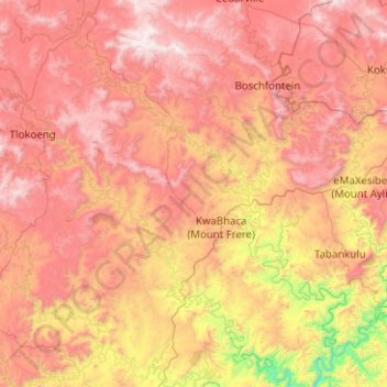
Name: Umzimvubu Local Municipality topographic map, elevation, terrain.
Average elevation: 1,255 m
Minimum elevation: 209 m
Maximum elevation: 2,268 m
Other topographic maps
Click on a map to view its topography, its elevation and its terrain.
Maluti
South Africa > Eastern Cape > Alfred Nzo District Municipality > Matatiele Local Municipality
Average elevation: 1,487 m
Ebenezer
South Africa > Eastern Cape > Alfred Nzo District Municipality > Mbizana Local Municipality
Average elevation: 109 m
Tina River
South Africa > Eastern Cape > Alfred Nzo District Municipality > Umzimvubu Local Municipality
Average elevation: 975 m
Cedarville
South Africa > Eastern Cape > Alfred Nzo District Municipality > Matatiele Local Municipality
Average elevation: 1,495 m
Cedarberg
South Africa > Eastern Cape > Alfred Nzo District Municipality > Matatiele Local Municipality
Average elevation: 1,634 m
KwaBhaca (Mount Frere)
South Africa > Eastern Cape > Alfred Nzo District Municipality > Umzimvubu Local Municipality
Average elevation: 1,116 m
Mzamba River
South Africa > Eastern Cape > Alfred Nzo District Municipality > Mbizana Local Municipality
Average elevation: 31 m