
Monument Beach topographic map
Interactive map
Click on the map to display elevation.
About this map
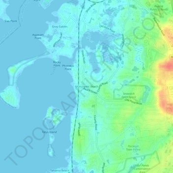
Name: Monument Beach topographic map, elevation, terrain.
Average elevation: 9 m
Minimum elevation: -3 m
Maximum elevation: 50 m
Other topographic maps
Click on a map to view its topography, its elevation and its terrain.
Buzzards Bay
United States > Massachusetts > Barnstable County > Bourne
Buzzards Bay, Bourne, Barnstable County, Massachusetts, 02532, United States
Average elevation: 6 m
Mt. Perry
United States > Massachusetts > Barnstable County > Bourne
Mt. Perry, Bourne, Barnstable County, Massachusetts, 02561, United States
Average elevation: 34 m
Bournedale
United States > Massachusetts > Barnstable County > Bourne > Bournedale
Bournedale, Bourne, Barnstable County, Massachusetts, 02531, United States
Average elevation: 29 m