
Les Crosets topographic map
Interactive map
Click on the map to display elevation.
About this map
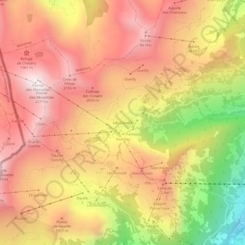
Name: Les Crosets topographic map, elevation, terrain.
Location: Les Crosets, Val-d'Illiez, Monthey, Valais, 1873, Suisse (46.16512 6.81568 46.20512 6.85568)
Average elevation: 1,773 m
Minimum elevation: 1,017 m
Maximum elevation: 2,262 m
Other topographic maps
Click on a map to view its topography, its elevation and its terrain.
Dents du Midi
Suisse > Valais > Monthey > Val-d'Illiez
Dents du Midi, Val-d'Illiez, Monthey, Valais, 1873, Suisse
Average elevation: 2,440 m