
Thank you for supporting this site ❤️
Make a donation
Make a donation
Saint Eustatius topographic map
Click on the map to display elevation.
Thank you for supporting this site ❤️
Make a donation
Make a donation
About this map
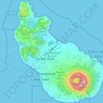
Name: Saint Eustatius topographic map, elevation, terrain.
Location: Saint Eustatius, Oranjestad, Sint Eustatius, Netherlands (17.46458 -63.00314 17.52605 -62.94591)
Average elevation: 50 m
Minimum elevation: 0 m
Maximum elevation: 559 m
Thank you for supporting this site ❤️
Make a donation
Make a donation