Geolocate

Skukuza Rest Camp topographic map

Interactive map

Click on the map to display elevation.

Skukuza Rest Camp topographic map, elevation, terrain

Skukuza Rest Camp topographic map, elevation, terrain

About this map

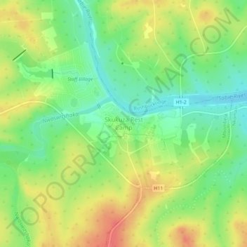
Name: Skukuza Rest Camp topographic map, elevation, terrain.

Location: Skukuza Rest Camp, Mbombela, Ehlanzeni District Municipality, Mpumalanga, South Africa (-25.01361 31.57144 -24.97361 31.61144)

Average elevation: 282 m

Minimum elevation: 253 m

Maximum elevation: 314 m

Other topographic maps

Click on a map to view its topography, its elevation and its terrain.

White River

South Africa > Mpumalanga > Ehlanzeni District Municipality > Mbombela

White River is located in the low altitude subtropical Lowveld climatic zone. Savannah and woodland scattered with granite outcrops form the indigenous habitat. Compared to other parts of South Africa, the climate is mild with good rainfall. Nevertheless, like the rest of South Africa, White River and its…

Average elevation: 902 m