
Cameron topographic map
Interactive map
Click on the map to display elevation.
About this map
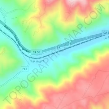
Name: Cameron topographic map, elevation, terrain.
Location: Cameron, Kern County, California, United States (35.08663 -118.30758 35.10663 -118.28758)
Average elevation: 1,309 m
Minimum elevation: 1,153 m
Maximum elevation: 1,519 m
Other topographic maps
Click on a map to view its topography, its elevation and its terrain.
Rosedale
United States > California > Kern County
Rosedale, Kern County, California, United States
Average elevation: 113 m
Upper Richbar Picnic Area
United States > California > Kern County
Upper Richbar Picnic Area, Kern County, California, United States
Average elevation: 658 m
Wasco
United States > California > Kern County
Wasco, Kern County, California, United States
Average elevation: 101 m
Mojave
United States > California > Kern County
Mojave, Kern County, California, United States
Average elevation: 857 m
Inyokern
United States > California > Kern County
Inyokern, Kern County, California, United States
Average elevation: 749 m
Baker
United States > California > Kern County > Boron
Baker, Boron, Kern County, California, United States
Average elevation: 765 m
Rosedale
United States > California > Kern County
Rosedale, Kern County, CAL Fire Contract Counties, California, United States
Average elevation: 107 m
Ridgecrest
United States > California > Kern County
Ridgecrest, Kern County, California, 93555, United States
Average elevation: 740 m
Lake Isabella
United States > California > Kern County
Lake Isabella, Kern County, California, United States
Average elevation: 979 m
Boron
United States > California > Kern County > Boron
Boron, Kern County, California, United States
Average elevation: 753 m
Tehachapi
United States > California > Kern County
Tehachapi, Kern County, California, 93561, United States
Average elevation: 1,414 m
Rio Bravo
United States > California > Kern County
Rio Bravo, Kern County, California, United States
Average elevation: 97 m
Bakersfield
United States > California > Kern County
Bakersfield, Kern County, California, United States
Average elevation: 157 m