
Thank you for supporting this site ❤️
Make a donation
Make a donation
San Antonio topographic map
Click on the map to display elevation.
Thank you for supporting this site ❤️
Make a donation
Make a donation
About this map
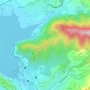
Name: San Antonio topographic map, elevation, terrain.
Average elevation: 1,854 m
Minimum elevation: 1,776 m
Maximum elevation: 2,090 m
Thank you for supporting this site ❤️
Make a donation
Make a donation
Other topographic maps
Click on a map to view its topography, its elevation and its terrain.
Presa Valle de Bravo
México > Estado de México > Valle de Bravo > Valle de Bravo
Average elevation: 1,826 m