
Thank you for supporting this site ❤️
Make a donation
Make a donation
Cristóbal topographic map
Click on the map to display elevation.
Thank you for supporting this site ❤️
Make a donation
Make a donation
About this map
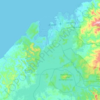
Name: Cristóbal topographic map, elevation, terrain.
Location: Cristóbal, Distrito de Colón, Colón, Panamá (9.11119 -80.04493 9.40565 -79.65618)
Average elevation: 46 m
Minimum elevation: -2 m
Maximum elevation: 438 m
Thank you for supporting this site ❤️
Make a donation
Make a donation
Other topographic maps
Click on a map to view its topography, its elevation and its terrain.