
Make a donation
Vulkaneifel topographic map
Click on the map to display elevation.
Make a donation
About this map
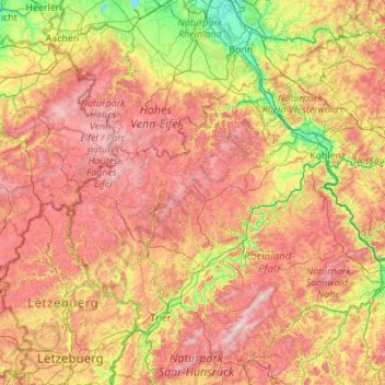
Name: Vulkaneifel topographic map, elevation, terrain.
Location: Vulkaneifel, Rhineland-Palatinate, 54550, Germany (49.51276 6.12790 50.91276 7.52790)
Average elevation: 339 m
Minimum elevation: 41 m
Maximum elevation: 809 m
Make a donation
Other topographic maps
Click on a map to view its topography, its elevation and its terrain.
Nürburg
Germany > Rhineland-Palatinate > Landkreis Ahrweiler
Nürburg has a semi-continental climate with both oceanic and continental tendencies. It does however land in the former category (Köppen Cfb). With regards to the racetrack, due to the Nordschleife's varied terrain and elevation, weather may be completely different on either end of the track. The elevation…
Average elevation: 560 m
Make a donation
Mainz
Germany > Rhineland-Palatinate
Nevertheless, the post-war reconstruction took place very slowly. While cities such as Frankfurt had been rebuilt fast by a central authority, only individual efforts were initially successful in rebuilding Mainz. The reason for this was that the French wanted Mainz to expand and become a model city. Mainz lay…
Average elevation: 132 m
Make a donation
Ramstein-Miesenbach
Germany > Rhineland-Palatinate > Landkreis Kaiserslautern
Average elevation: 266 m
Make a donation
Eltz Castle
Germany > Rhineland-Palatinate > Landkreis Mayen-Koblenz > Wierschem
Average elevation: 219 m
Make a donation
Deidesheim
Germany > Rhineland-Palatinate > Landkreis Bad Dürkheim
From a local climatic point of view, Deidesheim is part of the climatically favoured foothill zone of the Weinstraße region. With a mean elevation of 235 m above sea level at the forest's edge, the lands of the Deidesheim area reach down to some 130 m above sea level at the lower mid-slope area in the…
Average elevation: 194 m
Make a donation
Make a donation
Friedewald
Germany > Rhineland-Palatinate > Landkreis Altenkirchen (Westerwald)
Average elevation: 484 m
Make a donation
Monbijou
Germany > Rhineland-Palatinate > Südwestpfalz > Dietrichingen > Monbijou
Average elevation: 302 m
Make a donation
Nürburg
Germany > Rhineland-Palatinate > Landkreis Ahrweiler
Nürburg has a semi-continental climate with both oceanic and continental tendencies. It does however land in the former category (Köppen Cfb). With regards to the racetrack, due to the Nordschleife's varied terrain and elevation, weather may be completely different on either end of the track. The elevation…
Average elevation: 560 m
Make a donation
Make a donation
Ahr
Germany > Rhineland-Palatinate
Ahr (German pronunciation: [ˈaːɐ̯]) is a river in Germany, a left tributary of the Rhine. Its source is at an elevation of approximately 470 metres (1,540 ft) above sea level in Blankenheim in the Eifel, in the cellar of a timber-frame house near the castle of Blankenheim. After 18 kilometres (11 mi) it…
Average elevation: 367 m
Westerwald
Germany > Rhineland-Palatinate
The Westerwald (German pronunciation: [ˈvɛstɐvalt] ; literally 'Western forest') is a low mountain range on the right bank of the river Rhine in the German federal states of Rhineland-Palatinate, Hesse and North Rhine-Westphalia. It is a part of the Rhenish Massif (Rheinisches Schiefergebirge or Rhenish…
Average elevation: 290 m
Ramstein-Miesenbach
Germany > Rhineland-Palatinate > Landkreis Kaiserslautern
Average elevation: 266 m
Make a donation
Mainz
Germany > Rhineland-Palatinate
The destruction caused by the Bombing of Mainz in World War II led to the most intense phase of building in the history of the town. During the last war in Germany, more than 30 air raids destroyed about 80 per cent of the city's centre, including most of the historic buildings. The attack on the afternoon of…
Average elevation: 132 m
Make a donation
Carlsberg
Germany > Rhineland-Palatinate > Landkreis Bad Dürkheim
The municipality lies at the north edge of the Palatinate Forest between the Haardt range in the south and the Autobahn A 6 in the north in the Leiningerland at an elevation of 285 m above sea level. Carlsberg belongs to the Verbandsgemeinde of Leiningerland, whose seat is in Grünstadt.
Average elevation: 327 m
Make a donation
Make a donation
Mainz
Germany > Rhineland-Palatinate
The destruction caused by the Bombing of Mainz in World War II led to the most intense phase of building in the history of the town. During the last war in Germany, more than 30 air raids destroyed about 80 per cent of the city's centre, including most of the historic buildings. The attack on the afternoon of…
Average elevation: 132 m
Cochem
Germany > Rhineland-Palatinate > Landkreis Cochem-Zell
Cochem lies at an elevation of some 83 m above sea level and the municipal area measures 21.2 km2. The town centre with the outlying centre of Sehl upstream lies on the Moselle's left bank, while the constituent centre of Cond lies on its right. A further constituent centre, Brauheck, with its commercial area,…
Average elevation: 286 m
Make a donation
Make a donation
Wackernheim
Germany > Rhineland-Palatinate > Landkreis Mainz-Bingen > Ingelheim am Rhein
Average elevation: 220 m
Birgel
Germany > Rhineland-Palatinate > Landkreis Vulkaneifel
The municipality belongs to the Kalkeifel (“Limestone Eifel”) and lies on the southern edge of the Dollendorf Limestone Basin (Dollendorfer Kalkmulde). The elevation ranges from about 400 m above sea level on the Kyll at Crumpsmühle to about 526 m above sea level at the Hirzberg (mountain).
Average elevation: 450 m
Falkenstein
Germany > Rhineland-Palatinate > Donnersbergkreis
The linear settlement is located along an old pass road that reaches its highest elevation at 464 m (1522 ft). The village's main street is one of the steepest public roads in Germany with a 25% gradient. Along the road to Winnweiler the Falkensteiner Tal (Falkenstein Valley), known for its rock formations is…
Average elevation: 412 m
Make a donation
Laudert
Germany > Rhineland-Palatinate > Rhein-Hunsrück-Kreis
North of Laudert, cleft here and there by the Autobahn or high-voltage transmission lines, is an otherwise continuous expanse of higher-elevation forest growing above mainly greywacke bedrock. In these woods, roughly a kilometre away from the village, in a swampy area that once afforded protection against…
Average elevation: 490 m
Make a donation
Schönenberg-Kübelberg
Germany > Rhineland-Palatinate > Landkreis Kusel
The municipality of Schönenberg-Kübelberg lies in the Western Palatinate near the boundary with the Saarland some 15 km south of Kusel, and 10 km northeast of Homburg. The two Ortsteile lie at the edge of the Landstuhler Bruch (a hollow). Kübelberg on the long mountain ridge south of the Klingbach runs…
Average elevation: 268 m
Betzdorf
Germany > Rhineland-Palatinate > Landkreis Altenkirchen (Westerwald)
Average elevation: 277 m
Make a donation
Make a donation
Make a donation
Make a donation
Altenglan
Germany > Rhineland-Palatinate > Landkreis Kusel
The municipality lies in the uplands in the Western Palatinate on the river Glan, which is the village's namesake, at an elevation in the valley of some 200 m above sea level, although the elevations within municipal limits reach almost 400 m (Bistersberg 387 m on the Glan's left bank; Kalmet 390 m on the…
Average elevation: 305 m
Make a donation
Make a donation
Horhausen (Westerwald)
Germany > Rhineland-Palatinate > Landkreis Altenkirchen (Westerwald)
Average elevation: 310 m
Make a donation