
Conthey topographic map
Interactive map
Click on the map to display elevation.
About this map
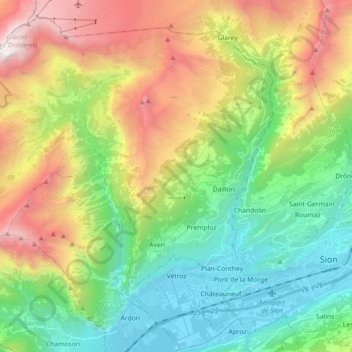
Name: Conthey topographic map, elevation, terrain.
Location: Conthey, Valais, 1964, Suisse (46.20412 7.15116 46.31640 7.33059)
Average elevation: 1,451 m
Minimum elevation: 473 m
Maximum elevation: 3,194 m
Other topographic maps
Click on a map to view its topography, its elevation and its terrain.
Haute Nendaz
Haute Nendaz, Nendaz, Conthey, Valais, 1997, Suisse
Average elevation: 1,144 m
Les Condémines
Suisse > Valais > Conthey > Les Condémines
Les Condémines, Nendaz, Conthey, Valais, 1997, Suisse
Average elevation: 1,012 m
Châteauneuf
Suisse > Valais > Conthey > Conthey > Châteauneuf
Châteauneuf, Conthey, Valais, 1964, Suisse
Average elevation: 541 m