
Thank you for supporting this site ❤️
Make a donation
Make a donation
Landslide Lake topographic map
Click on the map to display elevation.
Thank you for supporting this site ❤️
Make a donation
Make a donation
About this map
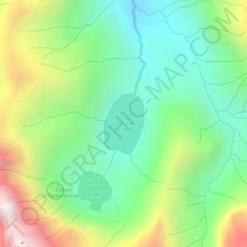
Name: Landslide Lake topographic map, elevation, terrain.
Average elevation: 1,186 m
Minimum elevation: 688 m
Maximum elevation: 2,116 m
Thank you for supporting this site ❤️
Make a donation
Make a donation
Other topographic maps
Click on a map to view its topography, its elevation and its terrain.
Vancouver Island Ranges
Canada > British Columbia > Area D (Oyster Bay/Buttle Lake)
Average elevation: 863 m