
Estômbar e Parchal topographic map
Interactive map
Click on the map to display elevation.
About this map
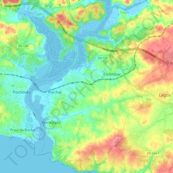
Name: Estômbar e Parchal topographic map, elevation, terrain.
Location: Estômbar e Parchal, Lagoa, Faro, Algarve, Portugal (37.10018 -8.53241 37.17988 -8.45246)
Average elevation: 29 m
Minimum elevation: -9 m
Maximum elevation: 84 m
Other topographic maps
Click on a map to view its topography, its elevation and its terrain.
Rio Arade
Portugal > Algarve > Estômbar e Parchal
Rio Arade, Estômbar e Parchal, Lagoa, Faro, Algarve, 8400-112, Portugal
Average elevation: 24 m
Parchal
Portugal > Algarve > Estômbar e Parchal
Parchal, Estômbar e Parchal, Lagoa, Faro, Algarve, Portugal
Average elevation: 10 m