
Thank you for supporting this site ❤️
Make a donation
Make a donation
Saxias topographic map
Click on the map to display elevation.
Thank you for supporting this site ❤️
Make a donation
Make a donation
About this map
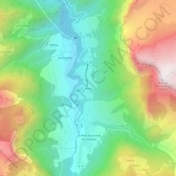
Name: Saxias topographic map, elevation, terrain.
Average elevation: 1,097 m
Minimum elevation: 599 m
Maximum elevation: 1,927 m
Thank you for supporting this site ❤️
Make a donation
Make a donation
Other topographic maps
Click on a map to view its topography, its elevation and its terrain.
Le Petit-Bornand-les-Glières
France > Auvergne-Rhône-Alpes > Haute-Savoie > Glières-Val-de-Borne
Les réserves d'eau situées en altitude sourdent souvent et font pleurer la falaise de Leschaux.
Average elevation: 1,366 m
Plan du Loup
France > Auvergne-Rhône-Alpes > Haute-Savoie > Glières-Val-de-Borne
Average elevation: 1,525 m