
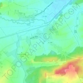
Hagenbach topographic map
Interactive map
Click on the map to display elevation.
About this map
Name: Hagenbach topographic map, elevation, terrain.
Average elevation: 300 m
Minimum elevation: 275 m
Maximum elevation: 361 m
Other topographic maps
Click on a map to view its topography, its elevation and its terrain.
Mülhausen
Frankreich > Grand Est > Oberelsass
Mülhausen, Oberelsass, Grand Est, Metropolitanes Frankreich, Frankreich
Average elevation: 254 m
Hohneck
Frankreich > Grand Est > Oberelsass > Stoßweier
Hohneck, Stoßweier, Colmar-Rappoltsweiler, Oberelsass, Grand Est, Metropolitanes Frankreich, 68140, Frankreich
Average elevation: 1,136 m
Franken
Frankreich > Grand Est > Oberelsass
Franken, Altkirch, Oberelsass, Grand Est, Metropolitanes Frankreich, 68130, Frankreich
Average elevation: 384 m
Gersbach
Frankreich > Grand Est > Oberelsass > Steinsulz
Gersbach, Steinsulz, Altkirch, Oberelsass, Grand Est, Metropolitanes Frankreich, 68640, Frankreich
Average elevation: 400 m
Wattweiler
Frankreich > Grand Est > Oberelsass
Wattweiler, Thann-Gebweiler, Oberelsass, Grand Est, Metropolitanes Frankreich, 68700, Frankreich
Average elevation: 434 m
Salfeld
Frankreich > Grand Est > Oberelsass > Mansbach
Salfeld, Mansbach, Altkirch, Oberelsass, Grand Est, Metropolitanes Frankreich, 68210, Frankreich
Average elevation: 361 m
Homburg
Frankreich > Grand Est > Oberelsass
Homburg, Mülhausen, Oberelsass, Grand Est, Metropolitanes Frankreich, 68490, Frankreich
Average elevation: 229 m
Orschweier
Frankreich > Grand Est > Oberelsass
Orschweier, Thann-Gebweiler, Oberelsass, Grand Est, Metropolitanes Frankreich, 68500, Frankreich
Average elevation: 351 m
Hecken
Frankreich > Grand Est > Oberelsass
Hecken, Altkirch, Oberelsass, Grand Est, Metropolitanes Frankreich, 68210, Frankreich
Average elevation: 308 m
Isenheim
Frankreich > Grand Est > Oberelsass
Isenheim, Thann-Gebweiler, Oberelsass, Grand Est, Metropolitanes Frankreich, 68500, Frankreich
Average elevation: 253 m
Querweg
Frankreich > Grand Est > Oberelsass > Ungersheim
Querweg, Ungersheim, Mülhausen, Oberelsass, Grand Est, Metropolitanes Frankreich, 68190, Frankreich
Average elevation: 220 m
Leimen
Frankreich > Grand Est > Oberelsass
Leimen, Mülhausen, Oberelsass, Grand Est, Metropolitanes Frankreich, 68220, Frankreich
Average elevation: 397 m
Hohrodberg
Frankreich > Grand Est > Oberelsass > Hohrod
Hohrodberg, Hohrod, Colmar-Rappoltsweiler, Oberelsass, Grand Est, Metropolitanes Frankreich, 68140, Frankreich
Average elevation: 696 m
Hirsingen
Frankreich > Grand Est > Oberelsass
Hirsingen, Altkirch, Oberelsass, Grand Est, Metropolitanes Frankreich, 68560, Frankreich
Average elevation: 366 m
Ensisheim
Frankreich > Grand Est > Oberelsass
Ensisheim, Thann-Gebweiler, Oberelsass, Grand Est, Metropolitanes Frankreich, 68190, Frankreich
Average elevation: 221 m
Col du Grand Ballon
Frankreich > Grand Est > Oberelsass > Sulz/Oberelsass
Col du Grand Ballon, Sulz/Oberelsass, Thann-Gebweiler, Oberelsass, Grand Est, Metropolitanes Frankreich, 68360, Frankreich
Average elevation: 1,143 m
Demberg
Frankreich > Grand Est > Oberelsass > Buhl
Demberg, Buhl, Thann-Gebweiler, Oberelsass, Grand Est, Metropolitanes Frankreich, 68530, Frankreich
Average elevation: 464 m
Bergholz
Frankreich > Grand Est > Oberelsass
Bergholz, Thann-Gebweiler, Oberelsass, Grand Est, Metropolitanes Frankreich, 68500, Frankreich
Average elevation: 275 m
Mittelstrasse
Frankreich > Grand Est > Oberelsass > Sankt Pilt
Mittelstrasse, Sankt Pilt, Colmar-Rappoltsweiler, Oberelsass, Grand Est, Metropolitanes Frankreich, 68590, Frankreich
Average elevation: 187 m
Colmar
Frankreich > Grand Est > Oberelsass
Colmar, Colmar-Rappoltsweiler, Oberelsass, Grand Est, Metropolitanes Frankreich, 68000, Frankreich
Average elevation: 233 m
Hohrod
Frankreich > Grand Est > Oberelsass
Hohrod, Colmar-Rappoltsweiler, Oberelsass, Grand Est, Metropolitanes Frankreich, 68140, Frankreich
Average elevation: 646 m
Heidweiler
Frankreich > Grand Est > Oberelsass
Heidweiler, Altkirch, Oberelsass, Grand Est, Metropolitanes Frankreich, 68720, Frankreich
Average elevation: 291 m
Dollern
Frankreich > Grand Est > Oberelsass
Dollern, Thann-Gebweiler, Oberelsass, Grand Est, Metropolitanes Frankreich, 68290, Frankreich
Average elevation: 642 m
Hameau Aloyse Merkling
Frankreich > Grand Est > Oberelsass > Goldbach-Altenbach
Hameau Aloyse Merkling, Goldbach-Altenbach, Thann-Gebweiler, Oberelsass, Grand Est, Metropolitanes Frankreich, 68760, Frankreich
Average elevation: 773 m
Urbach bei Kaysersberg
Frankreich > Grand Est > Oberelsass
Urbach bei Kaysersberg, Colmar-Rappoltsweiler, Oberelsass, Grand Est, Metropolitanes Frankreich, 68240, Frankreich
Average elevation: 730 m
Zellenberg
Frankreich > Grand Est > Oberelsass
Zellenberg, Colmar-Rappoltsweiler, Oberelsass, Grand Est, Metropolitanes Frankreich, 68340, Frankreich
Average elevation: 283 m
Münster im Elsass
Frankreich > Grand Est > Oberelsass
Münster im Elsass, Colmar-Rappoltsweiler, Oberelsass, Grand Est, Metropolitanes Frankreich, 68140, Frankreich
Average elevation: 529 m
Markstein
Frankreich > Grand Est > Oberelsass > Felleringen
Markstein, Felleringen, Thann-Gebweiler, Oberelsass, Grand Est, Metropolitanes Frankreich, 68470, Frankreich
Average elevation: 1,013 m
Goldbach-Altenbach
Frankreich > Grand Est > Oberelsass
Goldbach-Altenbach, Thann-Gebweiler, Oberelsass, Grand Est, Metropolitanes Frankreich, 68760, Frankreich
Average elevation: 852 m
Ranspach
Frankreich > Grand Est > Oberelsass
Ranspach, Thann-Gebweiler, Oberelsass, Grand Est, Metropolitanes Frankreich, 68470, Frankreich
Average elevation: 705 m
Mollau
Frankreich > Grand Est > Oberelsass
Mollau, Thann-Gebweiler, Oberelsass, Grand Est, Metropolitanes Frankreich, 68470, Frankreich
Average elevation: 691 m
Teufelskopf
Frankreich > Grand Est > Oberelsass > Urbach bei Kaysersberg
Teufelskopf, Urbach bei Kaysersberg, Colmar-Rappoltsweiler, Oberelsass, Grand Est, Metropolitanes Frankreich, 68240, Frankreich
Average elevation: 955 m
Storckensohn
Frankreich > Grand Est > Oberelsass
Storckensohn, Thann-Gebweiler, Oberelsass, Grand Est, Metropolitanes Frankreich, 68470, Frankreich
Average elevation: 675 m
Hartz
Frankreich > Grand Est > Oberelsass > Hattstatt
Hartz, Hattstatt, Thann-Gebweiler, Oberelsass, Grand Est, Metropolitanes Frankreich, 68420, Frankreich
Average elevation: 232 m
Kleiner Belchen
Frankreich > Grand Est > Oberelsass > Linthal
Kleiner Belchen, Linthal, Thann-Gebweiler, Oberelsass, Grand Est, Metropolitanes Frankreich, 68610, Frankreich
Average elevation: 1,050 m
Morzweiler
Frankreich > Grand Est > Oberelsass > Le Haut-Soultzbach
Morzweiler, Le Haut-Soultzbach, Thann-Gebweiler, Oberelsass, Grand Est, Metropolitanes Frankreich, 68780, Frankreich
Average elevation: 393 m
Buchenkopf
Frankreich > Grand Est > Oberelsass > Urbeis
Buchenkopf, Urbeis, Colmar-Rappoltsweiler, Oberelsass, Grand Est, Metropolitanes Frankreich, 68370, Frankreich
Average elevation: 994 m
Krüt
Frankreich > Grand Est > Oberelsass
Krüt, Thann-Gebweiler, Oberelsass, Grand Est, Metropolitanes Frankreich, 68820, Frankreich
Average elevation: 863 m
Reichweiler
Frankreich > Grand Est > Oberelsass
Reichweiler, Mülhausen, Oberelsass, Grand Est, Metropolitanes Frankreich, 68120, Frankreich
Average elevation: 248 m
Elbach
Frankreich > Grand Est > Oberelsass
Elbach, Altkirch, Oberelsass, Grand Est, Metropolitanes Frankreich, 68210, Frankreich
Average elevation: 332 m
Bretten
Frankreich > Grand Est > Oberelsass
Bretten, Altkirch, Oberelsass, Grand Est, Metropolitanes Frankreich, 68780, Frankreich
Average elevation: 362 m
Altweier
Frankreich > Grand Est > Oberelsass
Altweier, Colmar-Rappoltsweiler, Oberelsass, Grand Est, Metropolitanes Frankreich, 68150, Frankreich
Average elevation: 800 m
Häusern (Oberelsass)
Frankreich > Grand Est > Oberelsass
Häusern (Oberelsass), Colmar-Rappoltsweiler, Oberelsass, Grand Est, Metropolitanes Frankreich, 68420, Frankreich
Average elevation: 398 m
Wegscheid
Frankreich > Grand Est > Oberelsass
Wegscheid, Thann-Gebweiler, Oberelsass, Grand Est, Metropolitanes Frankreich, 68290, Frankreich
Average elevation: 637 m
Griesbach
Frankreich > Grand Est > Oberelsass
Griesbach, Colmar-Rappoltsweiler, Oberelsass, Grand Est, Metropolitanes Frankreich, 68140, Frankreich
Average elevation: 524 m
Kirchberg
Frankreich > Grand Est > Oberelsass
Kirchberg, Thann-Gebweiler, Oberelsass, Grand Est, Metropolitanes Frankreich, 68290, Frankreich
Average elevation: 614 m
Feldkirch
Frankreich > Grand Est > Oberelsass
Feldkirch, Mülhausen, Oberelsass, Grand Est, Metropolitanes Frankreich, 68540, Frankreich
Average elevation: 235 m
Schweighausen
Frankreich > Grand Est > Oberelsass
Schweighausen, Thann-Gebweiler, Oberelsass, Grand Est, Metropolitanes Frankreich, 68520, Frankreich
Average elevation: 299 m
Linthal
Frankreich > Grand Est > Oberelsass
Linthal, Thann-Gebweiler, Oberelsass, Grand Est, Metropolitanes Frankreich, 68610, Frankreich
Average elevation: 780 m
Jettingen
Frankreich > Grand Est > Oberelsass
Jettingen, Altkirch, Oberelsass, Grand Est, Metropolitanes Frankreich, 68130, Frankreich
Average elevation: 392 m