
Dagestan topographic map
Click on the map to display elevation.
About this map
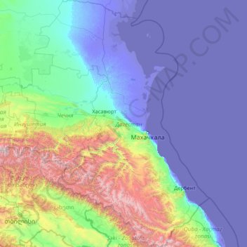
Name: Dagestan topographic map, elevation, terrain.
Location: Dagestan, North Caucasian Federal District, Russia (41.18510 45.10342 44.99172 48.80904)
Average elevation: 501 m
Minimum elevation: -31 m
Maximum elevation: 4,590 m
Other topographic maps
Click on a map to view its topography, its elevation and its terrain.
Novoromanovka
Russia > Republic of Dagestan > Tarumovsky District > Novoromanovka
Average elevation: -8 m