
Annapurna topographic map
Interactive map
Click on the map to display elevation.
About this map
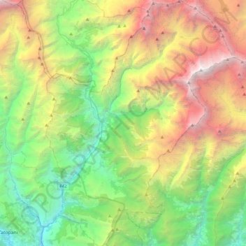
Name: Annapurna topographic map, elevation, terrain.
Location: Annapurna, म्याग्दी, Gandaki Pradesh, Nepal (28.34808 83.57239 28.69316 83.87029)
Average elevation: 3,389 m
Minimum elevation: 844 m
Maximum elevation: 8,033 m
Other topographic maps
Click on a map to view its topography, its elevation and its terrain.
Dhaulagiri
Nepal > Gandaki Pradesh > म्याग्दी
Dhaulagiri, Dhaulagiri-04, Dhaulagiri, म्याग्दी, Gandaki Pradesh, Nepal
Average elevation: 7,321 m