
Town of Zaprešić topographic map
Interactive map
Click on the map to display elevation.
About this map
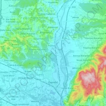
Name: Town of Zaprešić topographic map, elevation, terrain.
Location: Town of Zaprešić, Zagreb County, Croatia (45.82684 15.77076 45.96203 15.87895)
Average elevation: 190 m
Minimum elevation: 119 m
Maximum elevation: 585 m
Other topographic maps
Click on a map to view its topography, its elevation and its terrain.
Donja Pušća
Donja Pušća, Općina Pušća, Zagreb County, 10294, Croatia
Average elevation: 187 m