
Make a donation
Montgomery County topographic map
Click on the map to display elevation.
Make a donation
Montgomery County
Montgomery County, Maryland, presents a varied topography characterized by gently rolling hills and an elevation range that fluctuates from around 100 feet (30 meters) to 800 feet (244 meters) above sea level. The county lies at the boundary between the Piedmont Plateau and the Atlantic Coastal Plain, which imparts a mix of terrain types. The northern parts of the county are slightly more elevated, with terrain that includes ridges and valleys, while the southern regions near Washington, D.C. are flatter. Several notable natural features are present, such as the Potomac River along the county's southern edge, which adds to its diverse landscape. Streams, lakes, and reservoirs are scattered throughout, including the popular Seneca Creek and Triadelphia Reservoir, contributing to the area's scenic beauty and recreational opportunities.
Make a donation
About this map
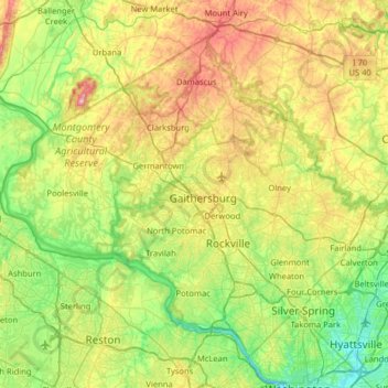
Name: Montgomery County topographic map, elevation, terrain.
Location: Montgomery County, Maryland, United States (38.93435 -77.52738 39.35432 -76.88766)
Average elevation: 120 m
Minimum elevation: -2 m
Maximum elevation: 368 m
Make a donation
Other topographic maps
Click on a map to view its topography, its elevation and its terrain.
Baltimore
United States > Maryland > Baltimore
Baltimore is in north-central Maryland on the Patapsco River close to where it empties into the Chesapeake Bay. The city is also located on the fall line between the Piedmont Plateau and the Atlantic coastal plain, which divides Baltimore into "lower city" and "upper city". The city's elevation ranges from sea…
Average elevation: 65 m
Make a donation
Make a donation
Make a donation
Highland
United States > Maryland > Frederick County
The majority of the downtown Highland district is situated within the 418-acre (169 ha) land grant named "Hickory Ridge". The Rouse Company borrowed the land grant name for one of its nearby villages of Columbia, built in 1974. The historic "White Hall" or "Hickory Ridge" estate (1749) was owned by the…
Average elevation: 357 m
Make a donation
Make a donation
Hoye-Crest
United States > Maryland > Garrett County
Hoye-Crest is a summit along Backbone Mountain just inside of Garrett County, Maryland. It is the highest natural point in Maryland at an elevation of 3,360 feet (1,020 m).
Average elevation: 887 m
Make a donation
Quiet Waters Park
United States > Maryland > Anne Arundel County > Annapolis > Georgetown East
Average elevation: 7 m
Make a donation
Make a donation
Make a donation
Make a donation
Make a donation
Make a donation
Antietam National Battlefield
United States > Maryland > Washington County > Sharpsburg
Average elevation: 147 m
Make a donation
Make a donation
Make a donation
Damascus
United States > Maryland > Montgomery County
As an unincorporated area, Damascus' boundaries are not officially defined. Damascus is recognized by the United States Census Bureau as a census-designated place, and by the United States Geological Survey as a populated place located at 39°16′16″N 77°12′22″W / 39.27111°N 77.20611°W /…
Average elevation: 204 m
Make a donation
Make a donation
Make a donation
Make a donation
Make a donation
Make a donation
Make a donation
Make a donation
Hydes Road Park
United States > Maryland > Baltimore County > Baldwin > Jenkins
Average elevation: 112 m
Make a donation
Make a donation