
Make a donation
Witset topographic map
Click on the map to display elevation.
Make a donation
About this map
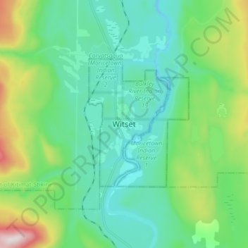
Name: Witset topographic map, elevation, terrain.
Location: Witset, British Columbia, V0J 3P0, Canada (54.98141 -127.36996 55.06141 -127.28996)
Average elevation: 518 m
Minimum elevation: 347 m
Maximum elevation: 1,087 m
Make a donation
Other topographic maps
Click on a map to view its topography, its elevation and its terrain.
Vancouver
Canada > British Columbia > Metro Vancouver Regional District
Vancouver, British Columbia, is situated on the Burrard Peninsula, bordered by Burrard Inlet to the north and the Fraser River to the south. The city's topography is a blend of flat and hilly terrains, with elevations ranging from sea level to approximately 152 meters (500 feet) above sea level. The North…
Average elevation: 34 m
Victoria
Canada > British Columbia > Capital Regional District
Victoria, British Columbia, is situated on the southern tip of Vancouver Island, Canada, and boasts a diverse and varied topography. The city is characterized by rolling hills, rugged coastal cliffs, and lush valleys, providing a striking contrast between mountainous terrain and flatland areas. To the north…
Average elevation: 17 m
Make a donation
Prince George
Canada > British Columbia > Regional District of Fraser-Fort George
The area has a humid continental climate (Köppen climate classification Dfb, Trewartha Dclo), but is close to (and once had) a subarctic climate (Dfc) as May and September averages are both close to the 10 °C (50 °F) threshold. Winters are milder than the latitude and elevation might suggest: the January…
Average elevation: 685 m
Burnaby
Canada > British Columbia > Metro Vancouver Regional District
Burnaby occupies 98.6 square kilometres (38.1 sq mi) and is located at the geographic centre of the Metro Vancouver Regional District. The regional district's government is located in Burnaby's Metrotown area. Situated between the city of Vancouver on the west and Port Moody, Coquitlam, and New Westminster on…
Average elevation: 59 m
Make a donation
Coquitlam
Canada > British Columbia > Metro Vancouver Regional District
Like much of Metro Vancouver, Coquitlam has an oceanic climate (Köppen climate type Cfb), experiencing mild temperatures and high precipitation; warm, dry summers and cool, wet winters. However, compared to most other cities in the area, precipitation is especially heavy in Coquitlam due to its proximity to…
Average elevation: 190 m
Vancouver
Canada > British Columbia > Metro Vancouver Regional District
Vancouver, British Columbia, is situated on the Burrard Peninsula, bordered by Burrard Inlet to the north and the Fraser River to the south. The city's topography is a blend of flat and hilly terrains, with elevations ranging from sea level to approximately 152 meters (500 feet) above sea level. The North…
Average elevation: 34 m
Kelowna
Canada > British Columbia > Regional District of Central Okanagan
Kelowna is classified as a humid continental climate or an inland oceanic climate per the Köppen climate classification system due to its coldest month having an average temperature slightly above −3.0 °C (26.6 °F) and below 0 °C (32 °F), with dry, hot, sunny summers and cool, cloudy winters, and four…
Average elevation: 704 m
Make a donation
Vancouver Island
The rain shadow effect of the island's mountains, as well as the mountains of Washington's Olympic Peninsula, creates wide variation in precipitation. The west coast is considerably wetter than the east coast. Average annual precipitation ranges from 6,650 mm (262 in) at Hucuktlis Lake on the west coast…
Average elevation: 411 m
Make a donation
Gabriola Island
Canada > British Columbia > Regional District of Nanaimo > Area B (DeCourcy/Gabriola/Mudge)
Gabriola is about 14 kilometres (9 mi) long by 4.2 kilometres (2.6 mi) wide on average with a land area of 57.6 square kilometres (22.2 sq mi). The topography varies from flat sandy beaches at sea level to forested hills rising to 160 metres (525 ft) on Stoney Ridge in the centre of the island.
Average elevation: 26 m
Make a donation
Mayne Island
Canada > British Columbia > Capital Regional District > Southern Gulf Islands Electoral Area > Mayne
Average elevation: 26 m
Township of Langley
Canada > British Columbia > Metro Vancouver Regional District
Average elevation: 47 m
Make a donation
Make a donation
Tsawwassen
Canada > British Columbia > Metro Vancouver Regional District > Delta
Average elevation: 12 m
Make a donation
Rossland
Canada > British Columbia > Regional District of Kootenay Boundary
Average elevation: 1,128 m
Osoyoos
Canada > British Columbia > Regional District of Okanagan-Similkameen
Average elevation: 326 m
Make a donation
Make a donation
Fraser River
Canada > British Columbia > Chilliwack > Hope > Deroche
Similar to the Columbia River Gorge east of Portland, Oregon, the Fraser exploits a topographic cleft between two mountain ranges separating a more continental climate (in this case, that of the British Columbia Interior) from a milder climate near the coast. When an Arctic high-pressure area moves into the…
Average elevation: 865 m
Area B (Shawnigan Lake)
Canada > British Columbia > Cowichan Valley Regional District
Average elevation: 301 m
Make a donation
Area B (Finlay Valley/Beatton Valley)
Canada > British Columbia > Peace River Regional District
Average elevation: 1,098 m
Penticton
Canada > British Columbia > Regional District of Okanagan-Similkameen
Penticton is located at the geographical coordinates of 49°29′28″N 119°35′19″W / 49.49111°N 119.58861°W / 49.49111; -119.58861 (Penticton) and covers an area of 42.10 km2 (16.25 sq mi), with a maximum north–south distance of 7 km (4.3 mi) wide between the Okanagan Lake to the north…
Average elevation: 702 m
Pemberton
Canada > British Columbia > Squamish-Lillooet Regional District
The climate of Pemberton is very warm and dry in the summer and mild and wet in the winter. Pemberton is an ecologically complex and diverse zone which is referred to as the Coast-Interior Transition zone. Moving from west to east in the direction of the prevailing winds and taking into consideration the…
Average elevation: 1,005 m
Make a donation
Hornby Island
Canada > British Columbia > Comox Valley Regional District > Area A (Baynes Sound)
Average elevation: 27 m
Make a donation
Enderby
Canada > British Columbia > Regional District of North Okanagan
Latitude-Longitude: 50°33′03.0″N 119°08′22.7″W / 50.550833°N 119.139639°W / 50.550833; -119.139639 elevation: 360 metres
Average elevation: 382 m
Chetwynd
Canada > British Columbia > Peace River Regional District
Carved out of an ancient floodplain, the small terrace upon which Chetwynd is situated lies in the northern foothills of the Rocky Mountains. Once used as a grazing spot by nomadic Aboriginals, the terrace was farmed by settlers until it was developed into a town. Two types of soil—namely, the Widmark and…
Average elevation: 910 m
Make a donation
Fort St. John
Canada > British Columbia > Peace River Regional District
Sitting at an elevation of 690 m (2,260 ft), Fort Saint John is situated within a low-lying valley near the eastern foothills of the Muskwa Ranges and Hart Ranges of the Northern Rockies. Prairies lie to the east and north, while to the west the Rocky Mountains form a rain shadow. The city is built on…
Average elevation: 676 m
Summerland
Canada > British Columbia > Regional District of Okanagan-Similkameen
Average elevation: 696 m
James Island
Canada > British Columbia > Capital Regional District > Southern Gulf Islands Electoral Area
James Island, one of British Columbia's Gulf Islands, lies in Haro Strait between Sidney Island and the coast of Vancouver Island near Sidney, British Columbia. James Island is approximately 2.4 km (1.5 mi) from the coast of Vancouver Island, and 145 km (90 mi) from Seattle, Washington. James Island has an…
Average elevation: 8 m
Make a donation
Harrison Hot Springs
Canada > British Columbia > Fraser Valley Regional District
Average elevation: 203 m
Mara Lake
Canada > British Columbia > Columbia-Shuswap Regional District > Area E (Eagle River Valley) > Swansea Point
The lake is 35.3 kilometres (21.9 mi) long. The surface area is about 1,943 hectares (4,800 acres) and elevation is 338 metres (1,109 ft) above sea level. The mean and maximum depth is 18 metres (59 ft).
Average elevation: 826 m
Make a donation
Vancouver East
Canada > British Columbia > Metro Vancouver Regional District > Vancouver
Average elevation: 25 m
South Surrey
Canada > British Columbia > Metro Vancouver Regional District > Surrey
Average elevation: 28 m
South Surrey
Canada > British Columbia > Metro Vancouver Regional District > Surrey
Average elevation: 28 m
Make a donation
False Creek
Canada > British Columbia > Metro Vancouver Regional District > Vancouver
Average elevation: 18 m
Make a donation
Mission
Canada > British Columbia > Fraser Valley Regional District
The western part of the district, the Stave Valley, is largely rural and forested but its watercourse is home to what was the largest hydroelectric project in British Columbia until the Bridge River Power Project opened in 1961. It was built by the British Columbia Electric Railway (BCER) to provide power to…
Average elevation: 345 m
Make a donation
Bowen Island
Canada > British Columbia > Metro Vancouver Regional District > Bowen Island Municipality
Average elevation: 106 m
Make a donation
Okanagan Lake
Canada > British Columbia > Regional District of Central Okanagan > Kelowna
Average elevation: 1,194 m
Make a donation
Red Lake
Canada > British Columbia > Thompson-Nicola Regional District > Area J (Copper Desert Country)
Average elevation: 1,036 m
Make a donation
Make a donation
Stanley Park
Canada > British Columbia > Metro Vancouver Regional District > Vancouver
Average elevation: 14 m
Make a donation
Make a donation