
Aschaffenburg topographic map
Interactive map
Click on the map to display elevation.
About this map
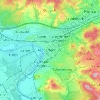
Name: Aschaffenburg topographic map, elevation, terrain.
Location: Aschaffenburg, Baja Franconia, Baviera, 63739, Alemania (49.93405 9.10936 50.01405 9.18936)
Average elevation: 173 m
Minimum elevation: 104 m
Maximum elevation: 345 m
Other topographic maps
Click on a map to view its topography, its elevation and its terrain.
Damm
Alemania > Baviera > Aschaffenburg
Damm, Aschaffenburg, Baja Franconia, Baviera, Alemania
Average elevation: 183 m