
Thank you for supporting this site ❤️
Make a donation
Make a donation
Rhineland-Palatinate topographic map
Click on the map to display elevation.
Thank you for supporting this site ❤️
Make a donation
Make a donation
About this map
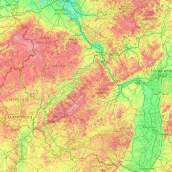
Name: Rhineland-Palatinate topographic map, elevation, terrain.
Location: Rhineland-Palatinate, Germany (48.96608 6.11225 50.94230 8.50831)
Average elevation: 296 m
Minimum elevation: 37 m
Maximum elevation: 882 m
Thank you for supporting this site ❤️
Make a donation
Make a donation
Other topographic maps
Click on a map to view its topography, its elevation and its terrain.
Thank you for supporting this site ❤️
Make a donation
Make a donation
Thank you for supporting this site ❤️
Make a donation
Make a donation
Finkenstein
Germany > Thuringia > Landkreis Schmalkalden-Meiningen > Steinbach-Hallenberg
Average elevation: 723 m
Westerberg
Germany > Lower Saxony > Landkreis Hameln-Pyrmont > Hessisch Oldendorf
Average elevation: 183 m
Thank you for supporting this site ❤️
Make a donation
Make a donation
Kogelberg
Germany > Bavaria > Landkreis Bad Tölz-Wolfratshausen > Lenggries
Average elevation: 1,020 m
Bernterode (bei Worbis)
Germany > Thuringia > Landkreis Eichsfeld > Bernterode (bei Worbis)
Average elevation: 306 m
Thank you for supporting this site ❤️
Make a donation
Make a donation