
East Fork White River topographic map
Interactive map
Click on the map to display elevation.
About this map
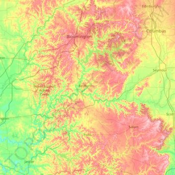
Name: East Fork White River topographic map, elevation, terrain.
Location: East Fork White River, Indiana, United States (38.49037 -87.24275 39.20618 -85.84830)
Average elevation: 200 m
Minimum elevation: 125 m
Maximum elevation: 316 m
Other topographic maps
Click on a map to view its topography, its elevation and its terrain.
Mitchell Plain
United States > Indiana > Washington County
Mitchell Plain, Washington County, Indiana, 47120, United States
Average elevation: 205 m
Cairo
United States > Indiana > Tippecanoe County
Cairo, Tippecanoe County, Indiana, United States
Average elevation: 212 m
Bass Lake
United States > Indiana > Starke County
Bass Lake, Starke County, Indiana, 45534, United States
Average elevation: 220 m
Goshen
United States > Indiana > Elkhart County
Goshen, Elkhart County, Indiana, United States
Average elevation: 252 m