
Harrison County topographic map
Interactive map
Click on the map to display elevation.
About this map
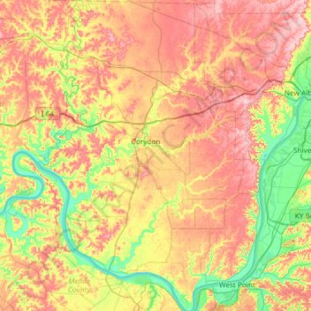
Name: Harrison County topographic map, elevation, terrain.
Location: Harrison County, Indiana, USA (37.95869 -86.33109 38.42240 -85.89986)
Average elevation: 205 m
Minimum elevation: 115 m
Maximum elevation: 308 m
Other topographic maps
Click on a map to view its topography, its elevation and its terrain.
Lawrenceburg
USA > Indiana > Lawrenceburg
Lawrenceburg, Lawrenceburg Township, Dearborn County, Indiana, USA
Average elevation: 168 m
Middle Fork of Wildcat Creek
Middle Fork of Wildcat Creek, Clinton County, Indiana, 46065, USA
Average elevation: 215 m
Fort Branch
USA > Indiana > Fort Branch
Fort Branch, Gibson County, Indiana, 47648, USA
Average elevation: 136 m
Dearborn County
Sparta Township, Dearborn County, Indiana, 47032, USA
Average elevation: 267 m
Saint Henry
USA > Indiana > Saint Henry
Saint Henry, Dubois County, Indiana, USA
Average elevation: 160 m
Holmesville
USA > Indiana > Holmesville
Holmesville, LaPorte County, Indiana, 46391, USA
Average elevation: 240 m