
Peynier topographic map
Interactive map
Click on the map to display elevation.
About this map
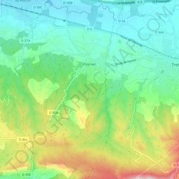
Name: Peynier topographic map, elevation, terrain.
Average elevation: 329 m
Minimum elevation: 207 m
Maximum elevation: 611 m
Other topographic maps
Click on a map to view its topography, its elevation and its terrain.
Albaron
France > Provence-Alpes-Côte d'Azur > Bouches-du-Rhône > Arles > Albaron
Albaron, Arles, Bouches-du-Rhône, Provence-Alpes-Côte d'Azur, Metropolitan France, 13123, France
Average elevation: 1 m
Saint-Rémy-de-Provence
France > Provence-Alpes-Côte d'Azur > Bouches-du-Rhône
Saint-Rémy-de-Provence, Arles, Bouches-du-Rhône, Provence-Alpes-Côte d'Azur, Metropolitan France, 13210, France
Average elevation: 100 m