
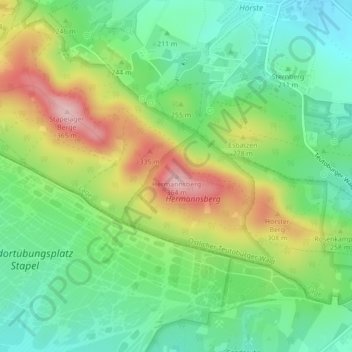
Hermannsberg topographic map
Interactive map
Click on the map to display elevation.
About this map
Name: Hermannsberg topographic map, elevation, terrain.
Average elevation: 232 m
Minimum elevation: 158 m
Maximum elevation: 353 m
Other topographic maps
Click on a map to view its topography, its elevation and its terrain.
Ehrentrup
Deutschland > Nordrhein-Westfalen > Kreis Lippe > Lage
Ehrentrup, Lage, Kreis Lippe, Nordrhein-Westfalen, 32791, Deutschland
Average elevation: 119 m
Heysundern
Deutschland > Nordrhein-Westfalen > Kreis Lippe > Lage > Breitenheide
Heysundern, Müssen, Breitenheide, Lage, Kreis Lippe, Nordrhein-Westfalen, 32791, Deutschland
Average elevation: 137 m
Hagen
Deutschland > Nordrhein-Westfalen > Kreis Lippe > Lage
Hagen, Lage, Kreis Lippe, Nordrhein-Westfalen, 32791, Deutschland
Average elevation: 101 m
Heiden
Deutschland > Nordrhein-Westfalen > Kreis Lippe > Lage
Heiden, Lage, Kreis Lippe, Nordrhein-Westfalen, 32758, Deutschland
Average elevation: 139 m
Stapelage
Deutschland > Nordrhein-Westfalen > Kreis Lippe > Lage
Stapelage, Lage, Kreis Lippe, Nordrhein-Westfalen, 32832, Deutschland
Average elevation: 199 m
Hörste
Deutschland > Nordrhein-Westfalen > Kreis Lippe > Lage > Stapelage
Hörste, Stapelage, Lage, Kreis Lippe, Nordrhein-Westfalen, Deutschland
Average elevation: 205 m