
Hingham Center topographic map
Interactive map
Click on the map to display elevation.
About this map
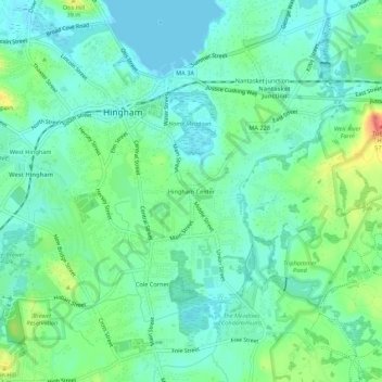
Name: Hingham Center topographic map, elevation, terrain.
Average elevation: 17 m
Minimum elevation: -2 m
Maximum elevation: 60 m
Other topographic maps
Click on a map to view its topography, its elevation and its terrain.
George Washington Forest
United States > Massachusetts > Plymouth County > Hingham > South Hingham
George Washington Forest, Huntley Road, South Hingham, Hingham, Plymouth County, Massachusetts, 02043, United States
Average elevation: 37 m
Old Spain
United States > Massachusetts > Plymouth County > Hingham
Old Spain, Hingham, Plymouth County, Massachusetts, 02043, United States
Average elevation: 11 m