
Thank you for supporting this site ❤️
Make a donation
Make a donation
Lindenthal topographic map
Click on the map to display elevation.
Thank you for supporting this site ❤️
Make a donation
Make a donation
About this map
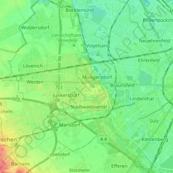
Name: Lindenthal topographic map, elevation, terrain.
Location: Lindenthal, Cologne, North Rhine-Westphalia, Germany (50.89324 6.80507 50.97830 6.94046)
Average elevation: 58 m
Minimum elevation: 38 m
Maximum elevation: 109 m
Thank you for supporting this site ❤️
Make a donation
Make a donation