
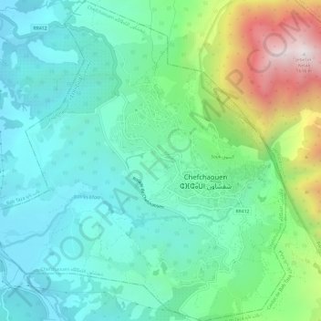
Chefchaouen ⵜⵛⴻⴼⵜⵛⴰⵡⴻⵏ شفشاون topographic map
Interactive map
Click on the map to display elevation.
About this map
Name: Chefchaouen ⵜⵛⴻⴼⵜⵛⴰⵡⴻⵏ شفشاون topographic map, elevation, terrain.
Average elevation: 619 m
Minimum elevation: 279 m
Maximum elevation: 1,600 m
Chefchaouen liegt im nordwestlichen Rif-Gebirge in einer Höhe von etwa 560 bis 600 m und etwa 62 km (Fahrtstrecke) südlich von Tétouan bzw. etwa 112 km südöstlich von Tanger, oberhalb des Flusses Laou. Das Klima ist gemäßigt bis warm; Regen (880 mm/Jahr) fällt nahezu ausschließlich im Winterhalbjahr.[2]
Other topographic maps
Click on a map to view its topography, its elevation and its terrain.
Chefchaouen ⴰⵛⵛⴰⵡⵏ شفشاون
Marokko > Chefchaouen ⴰⵛⵛⴰⵡⵏ شفشاون
Chefchaouen ⵛⴼⵛⴰⵡⵏ شفشاون, Chefchaouen ⴰⵛⵛⴰⵡⵏ شفشاون, Province de Chefchaouen ⵜⵛⴻⴼⵜⵛⴰⵡⴻⵏ إقليم شفشاون, Tanger-Tétouan-Al Hoceima ⵟⴰⵏⵊ-ⵟⵉⵜⴰⵡⵉⵏ-ⵍⵃⵓⵙⵉⵎⴰ طنجة-تطوان-الحسيمة, 91004, Marokko
Average elevation: 766 m