
Kamberk topographic map
Interactive map
Click on the map to display elevation.
About this map
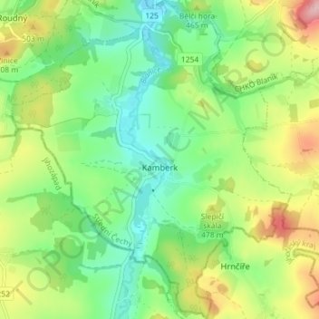
Name: Kamberk topographic map, elevation, terrain.
Location: Kamberk, okres Benešov, Central Bohemia, Czechia (49.57508 14.80722 49.62115 14.86984)
Average elevation: 448 m
Minimum elevation: 382 m
Maximum elevation: 565 m
Other topographic maps
Click on a map to view its topography, its elevation and its terrain.
CHKO Křivoklátsko
Czechia > Central Bohemia > Nezabudice
CHKO Křivoklátsko, 201, Nezabudice, okres Rakovník, Středočeský kraj, Central Bohemia, 27023, Czechia
Average elevation: 400 m