
Findhorn topographic map
Interactive map
Click on the map to display elevation.
About this map
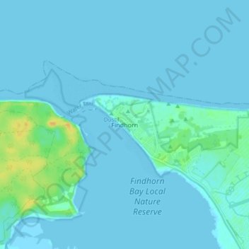
Name: Findhorn topographic map, elevation, terrain.
Location: Findhorn, Moray, Scotland, IV36 3YG, United Kingdom (57.63911 -3.63070 57.67911 -3.59070)
Average elevation: 3 m
Minimum elevation: -1 m
Maximum elevation: 24 m
Other topographic maps
Click on a map to view its topography, its elevation and its terrain.
Garmouth
United Kingdom > Scotland > Moray
Garmouth, Moray, Scotland, IV32 7PD, United Kingdom
Average elevation: 11 m
Dyke
United Kingdom > Scotland > Moray
Dyke, Moray, Scotland, IV36 2TJ, United Kingdom
Average elevation: 24 m
Forres
United Kingdom > Scotland > Moray
Forres, Moray, Scotland, IV36 1NX, United Kingdom
Average elevation: 31 m
Dunphail
United Kingdom > Scotland > Moray
Dunphail, Moray, Scotland, IV36 2QQ, United Kingdom
Average elevation: 192 m
Portgordon
United Kingdom > Scotland > Moray
Portgordon, Moray, Scotland, AB56 5TL, United Kingdom
Average elevation: 22 m