
Simola topographic map
Interactive map
Click on the map to display elevation.
About this map
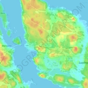
Name: Simola topographic map, elevation, terrain.
Average elevation: 11 m
Minimum elevation: -1 m
Maximum elevation: 34 m
Other topographic maps
Click on a map to view its topography, its elevation and its terrain.
Simola
Finland > Southern Finland > Simola
Simola, Loimaan seutukunta, Southwest Finland, South-Western Finland, Southern Finland, Mainland Finland, 21370, Finland
Average elevation: 53 m