
Thank you for supporting this site ❤️
Make a donation
Make a donation
Overlea topographic map
Click on the map to display elevation.
Thank you for supporting this site ❤️
Make a donation
Make a donation
About this map
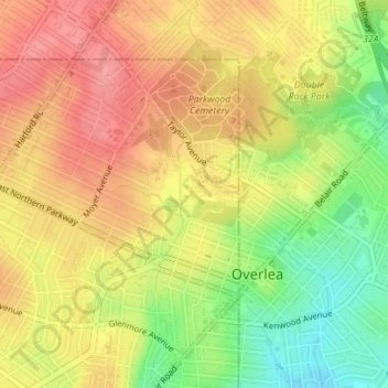
Name: Overlea topographic map, elevation, terrain.
Location: Overlea, Baltimore, Maryland, United States (39.35554 -76.54095 39.36958 -76.52968)
Average elevation: 80 m
Minimum elevation: 31 m
Maximum elevation: 114 m
Thank you for supporting this site ❤️
Make a donation
Make a donation
Other topographic maps
Click on a map to view its topography, its elevation and its terrain.