
Thank you for supporting this site ❤️
Make a donation
Make a donation
Klipriviersberg Nature Reserve topographic map
Click on the map to display elevation.
Thank you for supporting this site ❤️
Make a donation
Make a donation
About this map
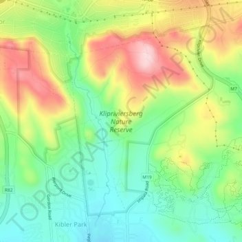
Name: Klipriviersberg Nature Reserve topographic map, elevation, terrain.
Average elevation: 1,634 m
Minimum elevation: 1,529 m
Maximum elevation: 1,787 m
Thank you for supporting this site ❤️
Make a donation
Make a donation
Other topographic maps
Click on a map to view its topography, its elevation and its terrain.
Melville Koppies
South Africa > Gauteng > City of Johannesburg Metropolitan Municipality > Johannesburg
Average elevation: 1,677 m
Melville Koppies Central
South Africa > Gauteng > City of Johannesburg Metropolitan Municipality > Johannesburg
Average elevation: 1,666 m
Melville Koppies
South Africa > Gauteng > City of Johannesburg Metropolitan Municipality > Johannesburg
Average elevation: 1,677 m
Melville Koppies
South Africa > Gauteng > City of Johannesburg Metropolitan Municipality > Johannesburg
Average elevation: 1,677 m
Thank you for supporting this site ❤️
Make a donation
Make a donation