
Thank you for supporting this site ❤️
Make a donation
Make a donation
Rojales topographic map
Click on the map to display elevation.
Thank you for supporting this site ❤️
Make a donation
Make a donation
About this map
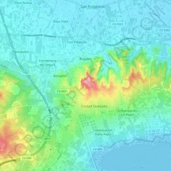
Name: Rojales topographic map, elevation, terrain.
Average elevation: 24 m
Minimum elevation: -6 m
Maximum elevation: 121 m
Thank you for supporting this site ❤️
Make a donation
Make a donation
Other topographic maps
Click on a map to view its topography, its elevation and its terrain.
Torremendo
Spanje > Valencia > el Baix Segura / La Vega Baja del Segura > Orihuela
Average elevation: 127 m
Barbarroja
Spanje > Valencia > el Baix Segura / La Vega Baja del Segura > Orihuela
Average elevation: 465 m
Villa Martín
Spanje > Valencia > el Baix Segura / La Vega Baja del Segura > Orihuela
Average elevation: 74 m
La Murada
Spanje > Valencia > el Baix Segura / La Vega Baja del Segura > Orihuela
Average elevation: 83 m
Thank you for supporting this site ❤️
Make a donation
Make a donation