
Make a donation
Goma topographic map
Click on the map to display elevation.
Make a donation
Goma
Goma is the largest and capital city of the North Kivu Province in eastern Democratic Republic of the Congo. To Goma's north lies Nyiragongo Territory, the Republic of Rwanda to the east, Lake Kivu to the south, and Masisi Territory to the west. Goma is strategically located on the Goma plain, which is composed of volcanic lavas and gradual slopes gently towards Lake Kivu. The plain is also bordered by the Virunga Mountains to the west, which comprises prominent peaks such as Nyamuragira, Mount Nyiragongo, Mount Mikeno, Mount Bisoke, Mount Gahinga, Mount Karisimbi and Mount Sabyinyo. Elevations in the northern part of the plain range from 1,640 to 2,000 m (5,380 to 6,560 ft), with the volcanic fields of Nyamuragira and Nyiragongo exhibiting continuous carbon dioxide degassing. Nyiragongo, in particular, has been active since the early 1900s, featuring an active lava lake and periodic eruptions, including notable events in 1977, 2002, and 2021.
Make a donation
About this map
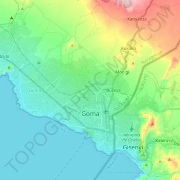
Name: Goma topographic map, elevation, terrain.
Location: Goma, North Kivu, Democratic Republic of the Congo (-1.70047 29.11525 -1.59511 29.26008)
Average elevation: 1,613 m
Minimum elevation: 1,454 m
Maximum elevation: 2,138 m
Make a donation
Other topographic maps
Click on a map to view its topography, its elevation and its terrain.