
Thank you for supporting this site ❤️
Make a donation
Make a donation
Ranger topographic map
Click on the map to display elevation.
Thank you for supporting this site ❤️
Make a donation
Make a donation
About this map
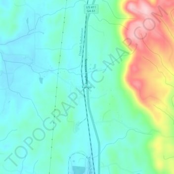
Name: Ranger topographic map, elevation, terrain.
Location: Ranger, Gordon County, Georgia, 30734, United States (34.48110 -84.72984 34.52110 -84.68984)
Average elevation: 265 m
Minimum elevation: 209 m
Maximum elevation: 423 m
Thank you for supporting this site ❤️
Make a donation
Make a donation
Other topographic maps
Click on a map to view its topography, its elevation and its terrain.