
Thank you for supporting this site ❤️
Make a donation
Make a donation
Alfaro topographic map
Click on the map to display elevation.
Thank you for supporting this site ❤️
Make a donation
Make a donation
About this map
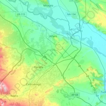
Name: Alfaro topographic map, elevation, terrain.
Location: Alfaro, La Rioja, 26540, Spanje (42.05844 -1.97227 42.22951 -1.67870)
Average elevation: 343 m
Minimum elevation: 252 m
Maximum elevation: 647 m
Thank you for supporting this site ❤️
Make a donation
Make a donation
Other topographic maps
Click on a map to view its topography, its elevation and its terrain.