
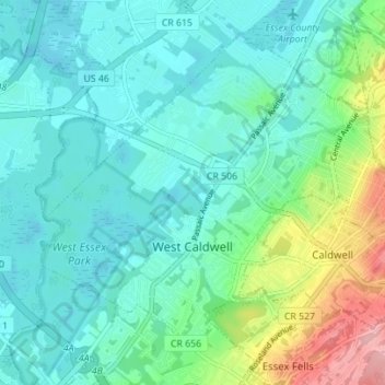
West Caldwell topographic map
Interactive map
Click on the map to display elevation.
About this map
Name: West Caldwell topographic map, elevation, terrain.
Average elevation: 76 m
Minimum elevation: 46 m
Maximum elevation: 178 m
Other topographic maps
Click on a map to view its topography, its elevation and its terrain.
Millburn
United States > New Jersey > Essex County
Millburn, Essex County, New Jersey, United States
Average elevation: 88 m
Newark
United States > New Jersey > Essex County
Newark, Essex County, New Jersey, United States
Average elevation: 22 m
Glen Ridge
United States > New Jersey > Essex County > Glen Ridge
Glen Ridge, Essex County, New Jersey, 07028, United States
Average elevation: 71 m
Short Hills
United States > New Jersey > Essex County > Short Hills
Short Hills, Millburn, Essex County, New Jersey, 07078, United States
Average elevation: 98 m