
Lochristi topographic map
Interactive map
Click on the map to display elevation.
About this map
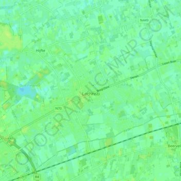
Name: Lochristi topographic map, elevation, terrain.
Location: Lochristi, Gent, Oost-Vlaanderen, 9080, België (51.07427 3.78661 51.12152 3.87893)
Average elevation: 6 m
Minimum elevation: 0 m
Maximum elevation: 11 m
Lochristi ligt in Zandig Vlaanderen en wel in het Waasland. De hoogte bedraagt ongeveer 8 meter. Vanaf de 2e helft van de 19e eeuw nam de teelt van begonia's en azalea's een grote vlucht. Er zijn nog steeds veel tuinbouwbedrijven. Een belangrijke waterloop is de Westlede, welke in oostelijke richting naar de Durme stroomt.
Other topographic maps
Click on a map to view its topography, its elevation and its terrain.
Lobos
België > Oost-Vlaanderen > Gent > Lochristi
Lobos, Lochristi, Gent, Oost-Vlaanderen, 9080, België
Average elevation: 6 m
Lozen Boer
België > Oost-Vlaanderen > Gent > Lochristi
Lozen Boer, Lochristi, Gent, Oost-Vlaanderen, 9080, België
Average elevation: 5 m
Beervelde
België > Oost-Vlaanderen > Gent > Lochristi
Beervelde, Lochristi, Gent, Oost-Vlaanderen, België
Average elevation: 6 m
Zaffelare
België > Oost-Vlaanderen > Gent > Lochristi
Zaffelare, Lochristi, Gent, Oost-Vlaanderen, België
Average elevation: 5 m
Zeveneken
België > Oost-Vlaanderen > Gent > Lochristi
Zeveneken, Lochristi, Gent, Oost-Vlaanderen, Vlaanderen, België
Average elevation: 5 m
Hijfte
België > Oost-Vlaanderen > Gent > Lochristi
Hijfte, Lochristi, Gent, Oost-Vlaanderen, Vlaanderen, 9080, België
Average elevation: 6 m