
Thank you for supporting this site ❤️
Make a donation
Make a donation
Maithan topographic map
Click on the map to display elevation.
Thank you for supporting this site ❤️
Make a donation
Make a donation
About this map
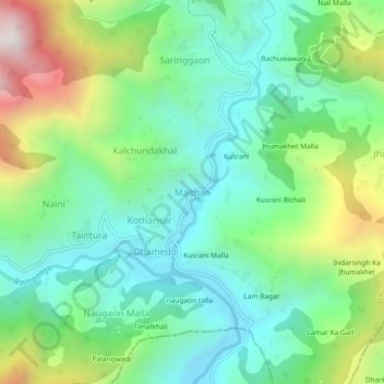
Name: Maithan topographic map, elevation, terrain.
Location: Maithan, Gairsain, Chamoli, Uttarakhand, 246486, India (29.93763 79.39017 29.97763 79.43017)
Average elevation: 1,414 m
Minimum elevation: 1,063 m
Maximum elevation: 2,209 m
Thank you for supporting this site ❤️
Make a donation
Make a donation