
Union County topographic map
Interactive map
Click on the map to display elevation.
About this map
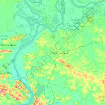
Name: Union County topographic map, elevation, terrain.
Location: Union County, Kentucky, United States (37.46977 -88.16019 37.90171 -87.73458)
Average elevation: 122 m
Minimum elevation: 97 m
Maximum elevation: 237 m
Other topographic maps
Click on a map to view its topography, its elevation and its terrain.
Lexington
United States > Kentucky > Lexington
Lexington, Fayette County, Kentucky, 40508, United States
Average elevation: 285 m
Winburn
United States > Kentucky > Fayette County > Lexington
Winburn, Lexington, Fayette County, Kentucky, United States
Average elevation: 292 m
Briartown
United States > Kentucky > Washington County > Springfield
Briartown, Springfield, Washington County, Kentucky, 40069, United States
Average elevation: 233 m
Ludlow
United States > Kentucky > Kenton County
Ludlow, Kenton County, Kentucky, 41016, United States
Average elevation: 182 m
Louisville
United States > Kentucky > Jefferson County > Louisville
Louisville, Jefferson County, Kentucky, 40202-2923, United States
Average elevation: 180 m
Vanceburg
United States > Kentucky > Lewis County
Vanceburg, Lewis County, Kentucky, 41179, United States
Average elevation: 226 m
Orchard Grass Hills
United States > Kentucky > Oldham County
Orchard Grass Hills, Oldham County, Kentucky, United States
Average elevation: 214 m
Murray
United States > Kentucky > Calloway County
Murray, Calloway County, Kentucky, United States
Average elevation: 159 m
East Bernstadt
United States > Kentucky > Laurel County
East Bernstadt, Laurel County, Kentucky, United States
Average elevation: 367 m
Sandhill
United States > Kentucky > Muhlenberg County
Sandhill, Muhlenberg County, Kentucky, 42369, United States
Average elevation: 143 m
McDowell
United States > Kentucky > Floyd County
McDowell, Floyd County, Kentucky, 41647, United States
Average elevation: 324 m
Indian Hills Cherokee Section
United States > Kentucky > Jefferson County > Indian Hills
Indian Hills Cherokee Section, Indian Hills, Jefferson County, Kentucky, 40207, United States
Average elevation: 168 m
Morning View
United States > Kentucky > Kenton County
Morning View, Kenton County, Kentucky, 41063, United States
Average elevation: 192 m
Broad Bottom
United States > Kentucky > Pike County
Broad Bottom, Pike County, Kentucky, 41659, United States
Average elevation: 274 m
Plumville
United States > Kentucky > Mason County
Plumville, Mason County, Kentucky, United States
Average elevation: 247 m
Lawrence County
Lawrence County, Kentucky, United States
Average elevation: 255 m
Carrollton
United States > Kentucky > Carroll County
Carrollton, Carroll County, Kentucky, United States
Average elevation: 170 m
Livingston County
Livingston County, Kentucky, United States
Average elevation: 131 m
Keaton
United States > Kentucky > Johnson County
Keaton, Johnson County, Kentucky, 41226, United States
Average elevation: 270 m
Owensboro
United States > Kentucky > Daviess County
Owensboro, Daviess County, Kentucky, United States
Average elevation: 123 m
Elizabethtown
United States > Kentucky > Hardin County
Elizabethtown, Hardin County, Kentucky, 42701, United States
Average elevation: 241 m
Aboretum
United States > Kentucky > Calloway County > Murray
Aboretum, Murray, Calloway County, Kentucky, United States
Average elevation: 168 m
Edsel
United States > Kentucky > Elliott County
Edsel, Elliott County, Kentucky, United States
Average elevation: 277 m
Dunmor
United States > Kentucky > Muhlenberg County
Dunmor, Muhlenberg County, Kentucky, 42339, United States
Average elevation: 179 m
Muhlenberg County
Muhlenberg County, Kentucky, United States
Average elevation: 144 m
Villa Hills
United States > Kentucky > Kenton County
Villa Hills, Kenton County, Kentucky, United States
Average elevation: 224 m
Oak Grove
United States > Kentucky > Christian County
Oak Grove, Christian County, Kentucky, 42262, United States
Average elevation: 170 m
Burtonville
United States > Kentucky > Lewis County
Burtonville, Lewis County, Kentucky, United States
Average elevation: 254 m
Buster Hill
United States > Kentucky > Wayne County > Monticello
Buster Hill, Monticello, Wayne County, Kentucky, 42633, United States
Average elevation: 295 m
Limp
United States > Kentucky > Hardin County
Limp, Hardin County, Kentucky, United States
Average elevation: 211 m
Danville
United States > Kentucky > Boyle County
Danville, Boyle County, Kentucky, United States
Average elevation: 290 m
Hindman
United States > Kentucky > Knott County
Hindman, Knott County, Kentucky, United States
Average elevation: 388 m
E.P. "Tom" Sawyer State Park
United States > Kentucky > Jefferson County > Louisville > Lakeland
E.P. "Tom" Sawyer State Park, Lakeland, Louisville, Jefferson County, Kentucky, United States
Average elevation: 209 m
Lebanon Junction
United States > Kentucky > Bullitt County
Lebanon Junction, Bullitt County, Kentucky, United States
Average elevation: 144 m
Gilbertsville
United States > Kentucky > Marshall County
Gilbertsville, Marshall County, Kentucky, United States
Average elevation: 104 m
Clark County
Clark County, Kentucky, 40391, United States
Average elevation: 273 m
Morehead
United States > Kentucky > Rowan County
Morehead, Rowan County, Kentucky, 40351, United States
Average elevation: 287 m
McConnell Springs
United States > Kentucky > Fayette County > Lexington
McConnell Springs, Lexington, Fayette County, Kentucky, United States
Average elevation: 287 m
Maysville
United States > Kentucky > Mason County
Maysville, Mason County, Kentucky, 41056, United States
Average elevation: 236 m
Guthrie
United States > Kentucky > Todd County
Guthrie, Todd County, Kentucky, United States
Average elevation: 172 m
Wilmore
United States > Kentucky > Jessamine County
Wilmore, Jessamine County, Kentucky, 40390, United States
Average elevation: 272 m
Dry Ridge
United States > Kentucky > Grant County
Dry Ridge, Grant County, Kentucky, United States
Average elevation: 274 m
Epperson
United States > Kentucky > McCracken County
Epperson, McCracken County, Kentucky, United States
Average elevation: 107 m
Hampton Manor
United States > Kentucky > Clark County > Winchester
Hampton Manor, Winchester, Clark County, Kentucky, 40391, United States
Average elevation: 297 m
Nicholasville
United States > Kentucky > Jessamine County
Nicholasville, Jessamine County, Kentucky, 40356, United States
Average elevation: 285 m