
Segovia topographic map
Interactive map
Click on the map to display elevation.
About this map
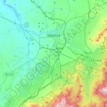
Name: Segovia topographic map, elevation, terrain.
Location: Segovia, Castile and León, Spain (40.83495 -4.33582 40.98799 -4.05245)
Average elevation: 1,142 m
Minimum elevation: 857 m
Maximum elevation: 2,188 m
Segovia is one of nine provinces that make up the autonomous region of Castile and León. Burgos and Valladolid lie to the north, Ávila to the west, Madrid to the south, and Soria to the east. The altitude of the province varies from 750 metres (2,461 feet) in the extreme northwest to a maximum of 2,430 m (7,972 ft) at Peñalara peak in the Sierra de Guadarrama.
Other topographic maps
Click on a map to view its topography, its elevation and its terrain.
Fuentepelayo
Fuentepelayo, Segovia, Castile and León, 40260, Spain
Average elevation: 875 m
Ayllón
Ayllón, Segovia, Castile and León, 40520, Spain
Average elevation: 1,123 m
San Justo
Spain > Castile and León > San Justo
San Justo, Galende, Castile and León, Spain
Average elevation: 1,332 m
La Tala
Spain > Castile and León > La Tala
La Tala, Guijuelo, Castile and León, Spain
Average elevation: 946 m
La Maya
Spain > Castile and León > La Maya
La Maya, Peñaranda de Bracamonte, Castile and León, Spain
Average elevation: 850 m
Burgos
Spain > Castile and León > Burgos
Burgos, Alfoz de Burgos, Burgos, Castile and León, Spain
Average elevation: 907 m
Velilla del Río Carrión
Spain > Castile and León > Velilla del Río Carrión
Velilla del Río Carrión, Palencia, Castile and León, 34886, Spain
Average elevation: 1,456 m
El Espinar
Spain > Castile and León > El Espinar
El Espinar, Segovia, Castile and León, Spain
Average elevation: 1,324 m
Pico Almanzor
Spain > Castile and León > Candeleda
Pico Almanzor, Candeleda, Comarca de Arenas de San Pedro, Ávila, Castile and León, Spain
Average elevation: 2,159 m
Atua
Spain > Castile and León > Condado de Treviño
Atua, Condado de Treviño, Ebro, Burgos, Castile and León, Spain
Average elevation: 629 m
Contreras
Spain > Castile and León > Contreras
Contreras, Sierra de la Demanda, Burgos, Castile and León, Spain
Average elevation: 1,089 m